| Re: Storm Éowyn set to batter the UK with up to 90mph winds - Friday 24 Jan 2025 Posted by CyclingSid at 14:55, 22nd January 2025 |     |
The Met Office https://weather.metoffice.gov.uk/forecast/gcn8t1p3y#?date=2025-01-24 forecasts gusting to Violent Storm 11 at Bournemouth. Fortunately in the early hours of Friday morning, so nobody should be at risk of having their deck chair and windbreak blown away.
Being a Southerly wind I would expect a fair amount of the beach to be dumped on the promenade. Not the conditions for the Brompton.
| Re: Storm Éowyn set to batter the UK with up to 90mph winds - Friday 24 Jan 2025 Posted by anthony215 at 12:03, 22nd January 2025 |     |
I can definitely se this being a bad one . They saying it's going to hit us with category 2 hurricane winds when it makes landfall
| Storm Éowyn set to batter the UK with up to 90mph winds - Friday 24 Jan 2025 Posted by Chris from Nailsea at 19:04, 21st January 2025 |     |
From the BBC:
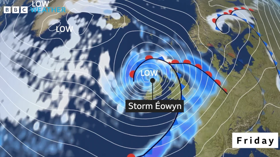
Storm Éowyn has been named by the Met Office and will bring severe gales to parts of the United Kingdom on Friday.
The Met Office has issued a yellow warning for wind on Friday and Saturday. Gusts of up to 90mph (145km/h) - or possibly even more - could bring localised damage, power cuts and travel disruption. Heavy rain and hill snow are also expected. It will mark a big change from the quiet and rather cold weather that has dominated over the last week or so.

Storm Éowyn – pronounced "ay-oh-win" – will undergo rapid development during Thursday as it moves across the Atlantic
While some of the details may still change, depending on the exact track Éowyn takes in the UK, the strongest winds on Friday are likely across parts of Northern Ireland, southern Scotland, northern and western areas of England and Wales.
The Met Office warns of gusts between 80-90mph (129-145km/h) around hills coastal areas of the Irish Sea. But widely gusts of 60-70mph (97-113km/h) are expected through the day. Elsewhere, across northern and western Scotland, parts of the Midlands and southern England, gusts of 50-65mph (80-105km/h) are expected but around coastal areas up to 80mph (129km/h). Met Office yellow warnings are likely to be adjusted and possibly upgraded ahead of Friday.
These gales and severe gales are likely to bring travel disruption and some damage, which could include roof tiles being blown off and power cuts. Large waves are also expected with coastal overtopping. Outbreaks of rain are also expected and while it will turn milder for some - especially in the south - it will remain cold enough for snow to fall over hills in Scotland, northern England and Northern Ireland.
The Met Office has issued a yellow warning for wind on Friday and Saturday. Gusts of up to 90mph (145km/h) - or possibly even more - could bring localised damage, power cuts and travel disruption. Heavy rain and hill snow are also expected. It will mark a big change from the quiet and rather cold weather that has dominated over the last week or so.

Storm Éowyn – pronounced "ay-oh-win" – will undergo rapid development during Thursday as it moves across the Atlantic
While some of the details may still change, depending on the exact track Éowyn takes in the UK, the strongest winds on Friday are likely across parts of Northern Ireland, southern Scotland, northern and western areas of England and Wales.
The Met Office warns of gusts between 80-90mph (129-145km/h) around hills coastal areas of the Irish Sea. But widely gusts of 60-70mph (97-113km/h) are expected through the day. Elsewhere, across northern and western Scotland, parts of the Midlands and southern England, gusts of 50-65mph (80-105km/h) are expected but around coastal areas up to 80mph (129km/h). Met Office yellow warnings are likely to be adjusted and possibly upgraded ahead of Friday.
These gales and severe gales are likely to bring travel disruption and some damage, which could include roof tiles being blown off and power cuts. Large waves are also expected with coastal overtopping. Outbreaks of rain are also expected and while it will turn milder for some - especially in the south - it will remain cold enough for snow to fall over hills in Scotland, northern England and Northern Ireland.
Please, be aware and take care out there. Chris.


